FOR IMMEDIATE RELEASE
Learning from Hurricane Michael
StEER post-event reconnaissance helps assess building response to historic storm
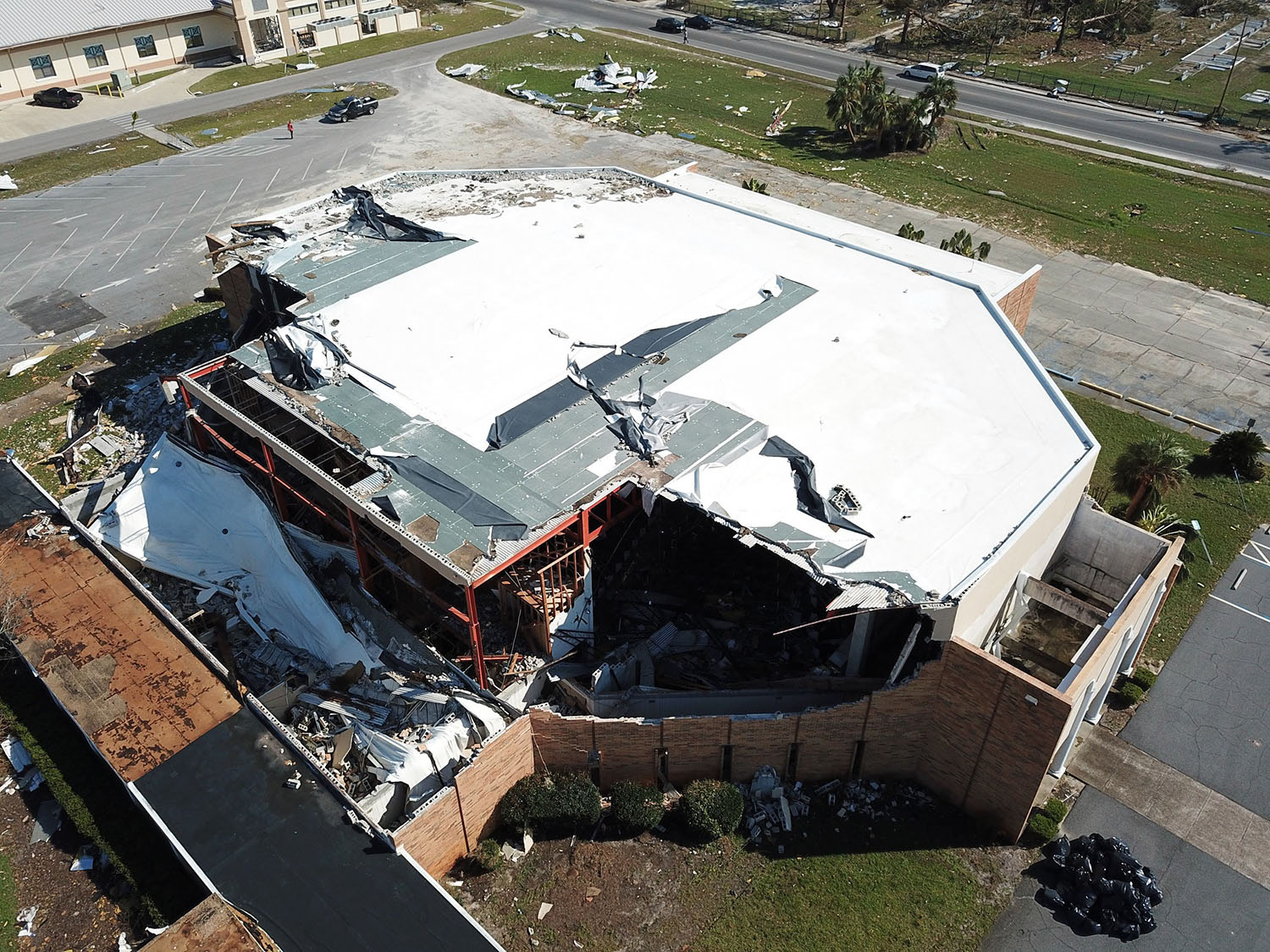
 Hurricane Michael devastated lives and property at the Florida panhandle in October 2018. Three days after it made landfall, the Structural Extreme Events Reconnaissance (StEER) Network gathered reliable data on building response such as this unmanned aerial vehicle image of roof cover and exterior wall failure of a gymnasium at the Bay County Prep Academy, Panama City, Florida. The dataset won a 2021 DesignSafe Dataset Award. Credit: StEER.
When Hurricane Michael made landfall in the Florida Panhandle on October 10, 2018, it made history.
Michaels 160-mph sustained winds helped make it the most powerful hurricane on record for the area. The Category 5 hurricane caused 74 deaths and $25.5 billion dollars of property damage. As people of the Florida coast picked up the pieces and tried to rebuild their lives from the hurricane, the questions remained: Would they be ready for the next big one? What could others learn from the aftermath?
The Structural Extreme Events Reconnaissance (StEER) Network aims to help communities answer that question through reliable post-event reconnaissance. StEER is part of the Natural Hazards Engineering Research Infrastructure (NHERI) program. It sends volunteer engineers to assess damage from hurricanes, tornadoes, earthquakes, and tsunamis. Both StEER and NHERI are funded by the National Science Foundation (NSF).
Just three days after the hurricane made landfall, StEER teams conducted assessments of building damage along a 130-mile stretch of the Florida panhandle centered on Panama City and the surrounding communities. They gathered hurricane damage data from unmanned aerial vehicles, laser scanners, and vehicle-mounted panoramic imaging systems.
The dataset, which includes over 302,000 individual photographs, was made publicly available on the NHERI DesignSafe cyberinfrastructure.
StEERs Hurricane Michael dataset was awarded a DesignSafe Dataset Award in 2021, which recognized the dataset's diverse contributions to natural hazards research.
As amazing as our experimental facilities and computational simulation tools are, in-situ observations continue to play a valuable role in documenting the true impacts of hazards on our built environment, said StEER principal investigator Tracy Kijewski-Correa, who is also an associate professor in the Department of Civil and Environmental Engineering & Earth Sciences, University of Notre Dame. Their complex interactions between at times multiple hazards reveal vulnerabilities to be addressed in our next generation structural mitigation solutions.
StEERs Advance Scout Team surveyed larger areas for rapid assessment of damage using the vehicle-mounted cameras of Applied StreetView technology. Post- Hurricane Michael footage of Panama City, Fla. Shown. Credit: StEER, DOI: 10.17603/ds2-5aej-e227
We believe, she added, this data is a valuable ground truth and the only truly authentic feedback loop on how our modeling and design assumptions fare against mother nature herself. We need to commit to learning from each event so we can mitigate these impacts in the future.
Some of the main findings from the dataset include observations of widespread wind- and surge-induced damage from Panama City Beach down to Apalachicola, with extensive joint wind- and surge-induced damage in Mexico Beach, where storm surge inundation of 8-12 feet was reported.
Other findings:
- Structural wind damage was widely observed in Panama City but was still highly variable.
- In Panama City Beach, and inland areas such as Marianna and Blountstown, structural damage was more isolated but roof cover and wall cladding damage was still frequently observed.
- In coastal regions, including Mexico Beach and Port St. Joe, multiple buildings were destroyed by the high winds but destruction was still not uniform.
- Storm surge was most prevalent from Mexico Beach down to the Big Bend, including Apalachicola.
- Structural surge-induced damage was mostly confined to an approximately one-mile stretch of Mexico Beach and portions of Port St. Joe.
- Washout of roads and coastal features was documented in multiple areas.
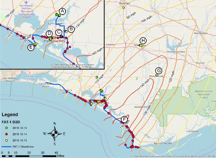
 Summary of StEER assessments relative to the peak gust wind speeds as estimated by Applied Research Associates, Inc. (ARA). (A) Southport, (B) Magnolia Hills, (C) Cedar Crossing, (D) Interior Panama City, (E) Pirates Cove Marina, (F) Mexico Beach & Beacon Hill, (G) Blountstown, (H) Marianna. Credit: StEER.
Anecdotally, the most extreme levels of damage were observed in older (pre-2002) structures, while newer structures generally performed much better. However, roof cover and wall cladding damage was still commonly observed even in newer structures. Failures were frequently observed in both engineered and non-engineered buildings.
The dataset is important because it captures near immediate perishable evidence of the performance of the built environment after Hurricane Michael, Kijewski-Correa said. It broadly assesses building performance over a large expanse of the impacted area and over a wide range of structural typologies.
The dataset has been used by StEER members and other natural hazards engineering researchers and practitioners in several ways. Immediately after the mission, the dataset enabled the selection of targets for follow-on studies funded by the Florida Building Commission and NSF RAPID Awards.
Other groups used the structural assessments to develop data-driven fragilities. The street-level panoramas and aerial imagery was used to virtually assess buildings that field teams could not evaluate in-depth with mobile apps. The laser scans enabled the reconstruction of specific structures for in-depth forensic evaluations of failure modes.
And other community members are using the images to train machine learning applications to extract building characteristics from imagery and classify damage.
Additionally, FEMA Mitigation Assessment Teams, the National Institute of Standards and Technology, and other agencies use the data as part of their response and assessment efforts for the event. The analysis of the data also results in recommendations to improve coastal planning and building codes, standards, and regulations.
The ultimate use case is the translation of knowledge gained into policy and practice to enhance the resilience of coastal communities, Kijewski-Correa said. In this case, the panhandles code requirements were able to be critically evaluated in light of the actual performance in Michael to consider how those should be revised in the future to avoid repeating these tragic lessons.
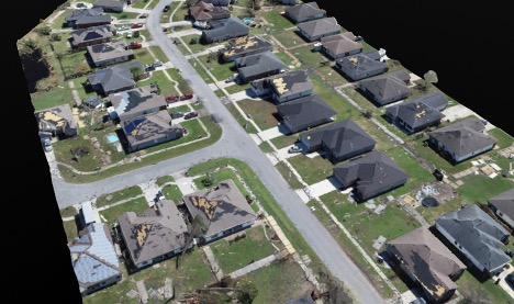
 Preliminary 3D model of a portion of the Cedar Crossing subdivision, created using Structure from Motion photogrammetry. Credit: StEER.
Collecting data within days of Hurricane Michael gave the StEER team the logistical challenges and stresses one might expect. The DesignSafe Slack channels proved to be useful in helping coordinate researchers.
The primary challenge with the datasets is quality control and documentation process. Making data reusable requires careful life cycle management as well as structuring the data and detailed documentation to capture everything needed for curation and re-use.
DesignSafe is critical to our mission of coordination in data collection and curation, Kijewski-Correa said. Our team always has challenging scenarios for DesignSafe in both evolving the Field Research Data Model and in transferring these large datasets from multiple platforms.
Weve worked closely with the DesignSafe team to learn together as we pioneer these workflows. Its our goal to help educate users in how to use DesignSafe resources most effectively.
Learn more: This webinar illustrates how StEER is encouraging community standards in support of DesignSafe.
The data collection was aided by partnerships with Spatial Networks, the Florida State Emergency Response Team, Marc Levitan of the National Institute of Standards and Technology, the University of Florida Coastal Monitoring Program under the leadership of Forrest Masters, as well as the NHERI community sharing intel on DesignSafes slack channel.
The data collection was led by a large team. For StEER that included David B. Roueche, Auburn University; John Cleary, University of South Alabama; Kurt Gurley, University of Florida; Justin Marshall, Auburn University; Jean-Paul Pinelli, Florida Institute of Technology; David O. Prevatt, University of Florida and Daniel Smith, James Cook University (Australia) and University of Florida.
For the RAPID EF that team included Jeffrey Berman, University of Washington; Jake Dafni, University of Washington and Sean Yeung, University of Washington.
The StEER data was quality controlled and enriched by a team of Data Librarians: (Kevin Ambrose, Auburn University; Christian Brown, Auburn University; Mohammadtaghi Moravej, Walker Consultants; Joseph Palmer, Auburn University; Hadiah Rawajfih, Auburn University; Madeline Rihner, Auburn University). Meanwhile, a team of Data Processors was also working at the RAPID EF: Jake Dafni, University of Washington; Dominic Grasso, Cornell University; Parker Johnson, University of Washington; Andrew Lyda, University of Washington and Emily Mongold, University of Delaware.
DesignSafe is a comprehensive cyberinfrastructure that is part of the NSF-funded Natural Hazard Engineering Research Infrastructure (NHERI) and provides cloud-based tools to manage, analyze, understand, and publish critical data for research to understand the impacts of natural hazards. The capabilities within the DesignSafe infrastructure are available at no-cost to all researchers working in natural hazards. The cyberinfrastructure and software development team is located at the Texas Advanced Computing Center (TACC) at The University of Texas at Austin, with a team of natural hazards researchers from the University of Texas, the Florida Institute of Technology, and Rice University comprising the senior management team.
NHERI is supported by multiple grants from the National Science Foundation, including the DesignSafe Cyberinfrastructure, Award #2022469.


